


Austin Ripper Maps
Eight Murders, 1885
Mollie Smith - 901 W Pecan St (6th & Bowie)
Eliza Shelley - 302 E Cypress St (3rd & San Jacinto)
Irene Cross - 302 E Linden St (17th & San Jacinto)
Mary Ramey - 300 E Cedar St (4th & San Jacinto)
Orange Washington - 2408 Guadalupe St
Grace Vance - 2408 Guadalupe St
Susan Hancock - 203 E Water St (Cesar Chavez & San Jacinto)
Eula Phillips - 306 W Hickory St (8th & Lavaca)

Servant Girl Burglaries, 1885.
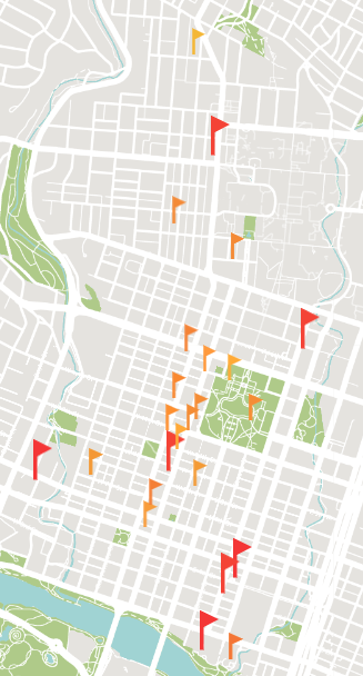
The red flags are the murders. The orange flags are night time burglaries and attempted burglaries against servant women in 1885. There are many more that are not marked on this map. They fall into a cluster in the center of the murders.
1885 Map of Austin
In 1885, Austin was a little over 4 square miles. The rectangular cluster of wards labeled E is now downtown Austin, or the original square mile. Most attacks and murders occurred in this area.


“The Original Square Mile”
You’re right, it’s not a square. Technically this is called the 1839 city plan, but today we call it Downtown ATX.